
1. What’s our current density?
Olympia – 18.22 sq. mi., 52,555 people = 2,884/sq. mi.
Tumwater – 17.5 sq. mi., 23,688 people = 1,353/sq. mi.
Lacey – 17.2 sq. mi., 50,718 people = 2,949/sq. mi.
Seattle (by way of comparison) – 83.87 sq. mi., 744,955 people = 8,882/sq. mi.
2. Do we have a sprawl problem?
As part of our planning under the Growth Management Act, TRPC does Buildable Lands Reports. The last one was in 2014; a new one is scheduled for next year. This graph shows the percentage of new housing units constructed within the cities (including their uniform growth areas, which are scheduled to be annexed once they get enough built in them to make that feasible) and the percentage of new units in the rest of the county.
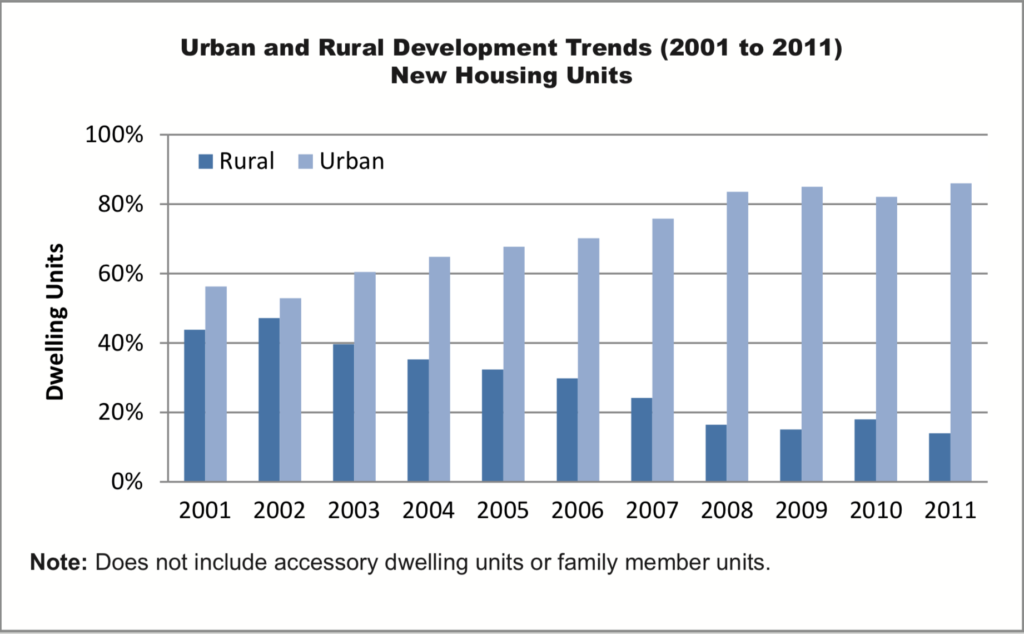
As you can see, the percentage of development going into rural areas has been getting smaller, year after year. (In 2014, TRPC forecasted that 13% of the units built over the next twenty years would be in “rural” areas outside the urban growth boundaries. This went up to 15.8% for the 2015-2019 period, though. That was about 190 new homes a year in rural areas of the County. The Sustainable Thurston target is 5%.)
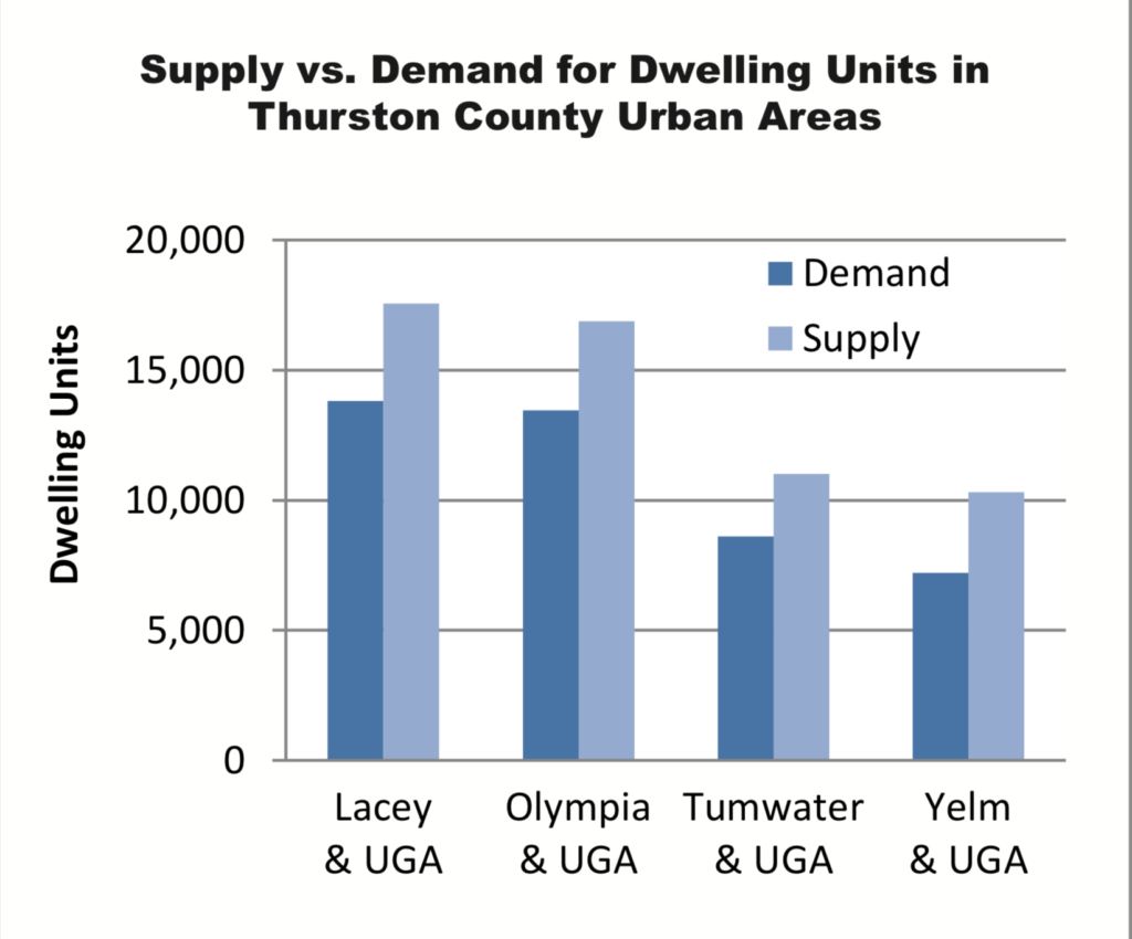
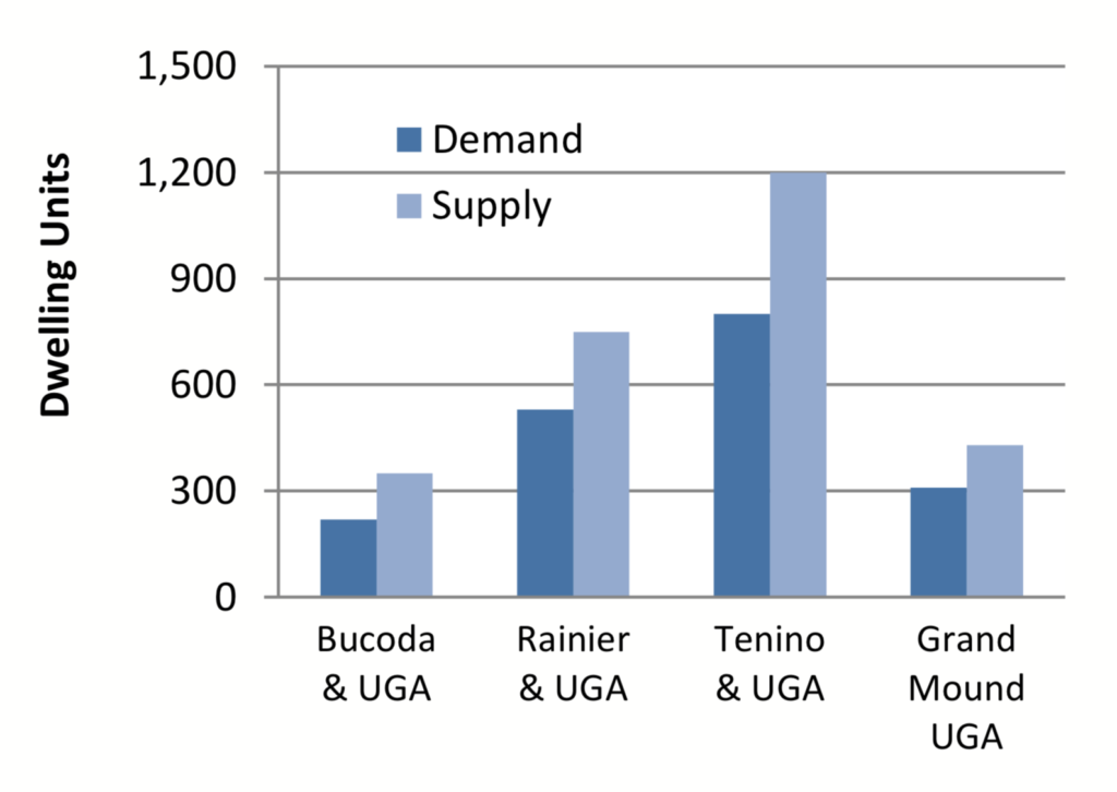
The next two graphs show TRPC’s estimates of the need for land to accommodate new housing units through 2035 versus the land that’s already available for building them in each city (including their UGAs).
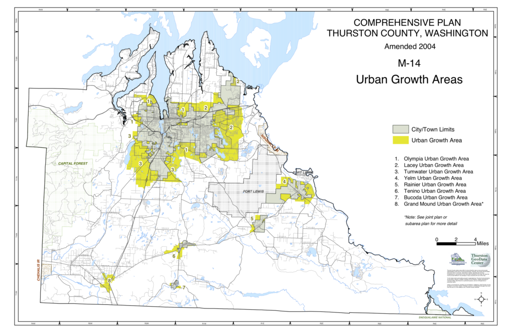
This map shows the UGAs, so you can get a rough sense of how big they are, and maybe about how much farther from the center of things you’d be if you lived in the UGA instead of within the current city boundaries. (From the legend in the bottom right of the map it looks as living on the outside edge of the largest UGAs would put you about three miles farther from the center of the city.)
3. What’s being proposed to increase density?
(Unless you’re really interested in the politics of land use planning, you might want to skip this section…)
In the 2019 session, the Legislature passed HB1923, which became effective at the end of July 2019. It encouraged cities to take various steps to increase density in their urban growth areas, and exempted those from legal challenges under the State Environmental Policy Act and the Growth Management Act if they were taken before April 2021. (This was a considerably milder version of HB2780; that would simply have required cities with more than 15,000 people to upzone all single family residential areas to include areas allowing duplexes, triplexes, quadplexes, sixplexes, stacked flats, townhouses, and courtyard apartments, and to allow a triplex on any lots that allowed a single-family residence. It didn’t include any exemptions from appeal, though. It didn’t get out of committee.)
HB1923 encouraged various steps to increase density, which I’m summarizing and combining to be brief.
1. Upzone to allow more residential units near commuter rail, light rail, and bus service that runs at least every fifteen minutes at least 12 hours a day. (The only IT bus that currently meets this frequency standard is #13, which runs on Capitol Boulevard from downtown to the Labor and Industries Building in Tumwater at 15 minute intervals for exactly 12 hours, from 6AM to 6PM, and on the half hour after that.) The bill specified zoning at least 500 acres with at least 25 units/acre through this provision in cities the size of Olympia and Tumwater, and at least 250 acres in cities the size of Tumwater.
2. Upzone to allow at least one duplex, triplex, or courtyard apartment on every parcel in one or more single-family residential districts unless there are specific infrastructure or physical constraints that would make it unfeasible for a particular parcel;
3. Authorize cluster zoning or lot size averaging in all single-family residential districts.
4. Authorize accessory dwelling units on all lots in those districts, subject to certain restrictions;
5. Adopt a subarea plan with special regulations for a mixed-use or urban center identified in a land use or transportation plan adopted by a regional transportation planning organization; or a plan for an area within 0.5 miles of a major transit stop that’s zoned for at least fifteen units per acre.
6. Adopt a planned action under the State Environmental Policy Act (SEPA). (This does environmental review for an area in advance of anyone filing permits, simplifying the process for actual development proposals later.)
7. Increase the exemptions from requirements that SEPA allows for accommodating infill development to include all single-family and multifamily development;
8. Adopt a form-based code in one or more zoning districts that permit residential uses;
9. Authorize a duplex on each corner lot within all single-family residential districts;
10. Allow using the simpler short subdivision process for dividing land into up to nine lots, rather than just when creating four or fewer.
11. Require a minimum net density of six units per acre in all residential zones. (Olympia’s current average density is 5.6 units/acre.)
A number of bills to increase density further were introduced in the 2020 session. I haven’t followed most of them; I think HB2343, which passed and which made various changes and additions to last year’s bill, was the significant one. Its additions are summarized on my website about the climate legislation in the 2020 session.
4. What’s been proposed in Olympia as changes to increase density in the “Missing Middle”?
Olympia’s ordinance was 193 pages long, though that was mostly the texts of current statues that were being amended in small ways. I think that the basic changes it made are summarized in a document that was part of the packet for the Council at the November 5th, 2018 meeting where they adopted the ordinance. (I think the ordinance also made other changes to make more lots usable for buildings besides single-family houses, like reducing setbacks and lowering minimum lot sizes.) The City was sued by a group of citizens, and the ordinance was invalidated by the Growth Management Hearings Board on the grounds that the City had failed to do an adequate environmental analysis in a number of ways, and that the results would be in actual conflict with several comprehensive plan goals. (This included a finding that the combination of increased density and reduced parking requirements would conflict with goals about maintaining and enhancing the character and livability of neighborhoods, but the Board didn’t rule in favor of the citizens as far as a number of their other claims about the negative effects of the changes on neighborhoods were concerned, for somewhat technical reasons.) The City lost an appeal of the decision, but is still pursuing another appeal in Superior Court. In the meantime, it’s moving forward to implement the three items in the list from HB1923 that seem likeliest to increase density and that the bill exempted from appeals – authorizing more ADUs, authorizing duplexes on all corner lots, and upzoning to allow duplex, triplex, or courtyard apartments in residential neighborhoods.
The City’s current proposal for increasing density, which is on the Planning Commission’s agenda, would allow ADUs on pretty much every lot in residential zones; would allow absentee ownership and the separate rental or sale of the main residence and the ADU; would remove the on-site parking requirements for them; would increase their maximum allowed size to 1,000 sq. ft.; would limit impact fees to the actual impact of the ADU; and would consider raising the height limit to allow building them above garages and shops. It would allow a duplex on any corner lot in residential zoning districts, but would require four on-site parking spaces rather the two required for a single family residence. It would have Council consider a variety of options for allowing duplexes, triplexes, or courtyard apartments on each parcel in one or more zoning districts that permit single-family residences.
5. What difference in density would these changes allow?
TRPC did a GIS based residential capacity analysis for the City as part of process for the Missing Middle proposal, examining each parcel and evaluating the theoretical maximum number of dwellings that could be built if those proposed changes were adopted. (It didn’t consider potential additional ADUs or internal conversions, like dividing an existing single family home into a duplex.) The map shows the areas in which those proposed changes would allow additional units.
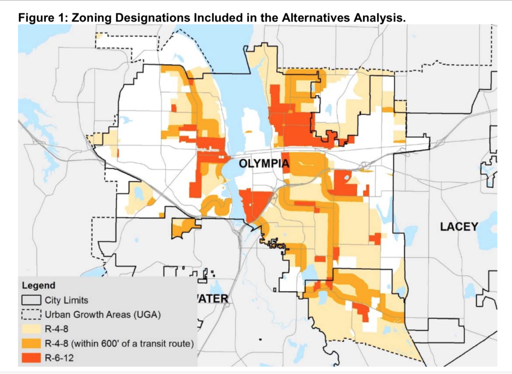
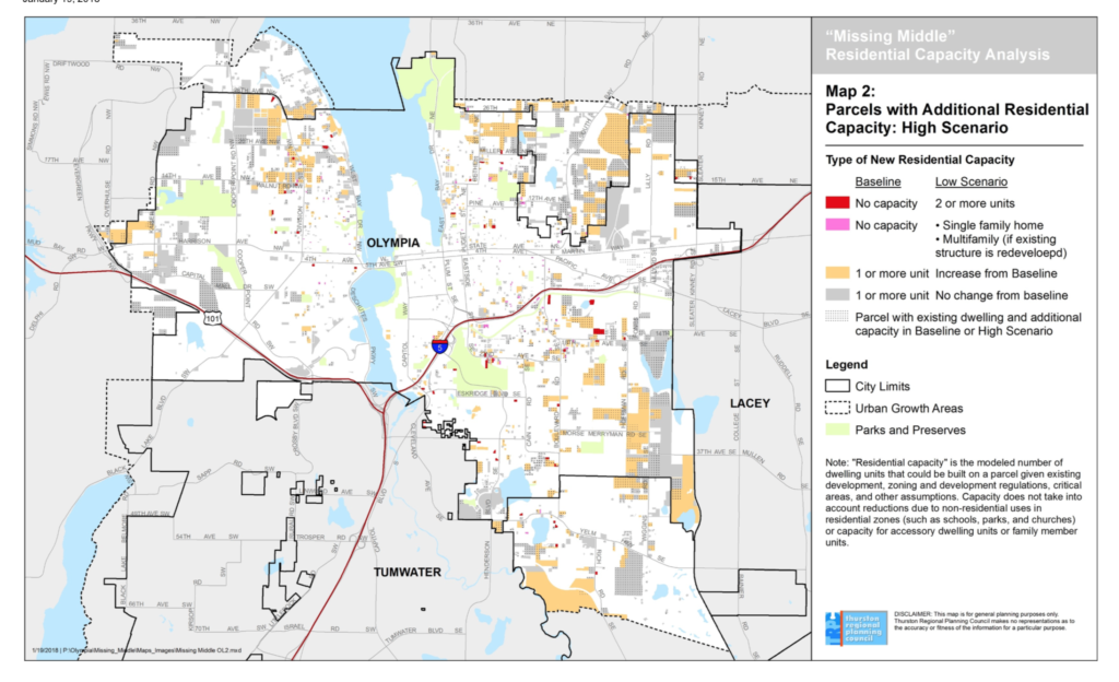
They concluded that the proposed changes would allow up to 946 additional housing units to be constructed, 161 more in the UGA and the rest within the current city limits. They’d almost all be in duplexes, triplexes, and courtyard apartments. (There would be about 100 currently built parcels that only allow a single family residence under the present rules, but would allow a multi-family residence as a result of the changes; TRPC estimated that about thirty of those are in such poor shape they’d probably be demolished and redeveloped.) From this next map, on which the light orange shows the locations of the actual potential additional units, it looks to me as if none of it is close to transit corridors except for an area around Division, even though the zones in which the changes are being made, show in the previous map, do run along transit corridors.
It also isn’t clear that allowing a lot more ADUs will mean a lot more of them get built. Many people who own homes on lots that would allow them to build an ADU don’t want to because they don’t want to give up that area of the yard, or because they don’t want to be landlords, or because they don’t want a renter right next door. It isn’t even clear that allowing absentee ownership will change this very much. According to some of the research on the City’s website, Portland allows ADUs on the great majority of its single-family lots, doesn’t require off street parking, and has allowed absentee ownership since at least 2008. However, as of 2014, it had only permitted ADUs on 800 parcels out of about 148,000 where they were allowed. (I think there’s been more recent interest, and Portland’s now getting about 500 applications a year, but that’s not very significant in a city of 653,000.) Lacey and Tumwater already allow absentee ownership of ADUs; I don’t know if that’s made any significant difference in how many they’ve permitted in recent years compared to Olympia.
6. What would the net benefit for climate of this increased density be?
I assume that there are really two separate housing markets – generally, people who want to rent a place are not going to buy a single family home if there’s a shortage of rentals, and people who want to buy a house aren’t not very likely to decide to rent instead (though I suppose some of them might consider buying a condo if they don’t care about having a yard for kids or pets.) If that’s right, it doesn’t seem as if having a surplus of multi-family units and a shortage of single family houses will mean that a larger percentage of the population shifts to living in multi-family buildings. Maybe it will mean that prices go up until more single family homes get built, and/or that people who want single family homes decide to buy them farther away than they would otherwise.
Multi-family housing offers some energy efficiency benefits because of shared walls, but it also has some efficiency drawbacks unless it’s sub-metered and the tenants pay their own utility bills. In any case, as far as I can see, those benefits don’t depend on where the multi-family building is located; we’d get those whether it was inside the urban growth area or not.
As far as I can see, what we’re trying to estimate is how much difference it would make to have about 1,000 housing units, maybe 2,500 people or so, living in the UGA or living outside it. From one point of view, these extra spaces make very little difference, since as the graphs in the very beginning show, each city already has a surplus of building spaces inside its UGA. Squinting at the graphs, those surpluses look to me as if they already each have room for between 3,000 and 5,000 more units than TRPC estimates we’re going to need to build by 2035.
If we actually did need these extra spaces, and we didn’t have them, and all those people settled in the country at once instead of over the next fifteen years, and if they each drove an extra thirty miles a day as a result, that would be an extra 27 million miles a year, burning an extra 1.24 million gallons of gas. That would produce about 11,000 tonnes of CO2e, and would add about 1.3% to our inventoried passenger vehicle and light truck emissions.